Fact within fiction
The sights and sounds of the Pringle family’s journey from Irvine to Greenock
( the notes on sources are in the pdf of this article - downloadable here )
John Galt set many of his stories in the Scotland of his day, often in the West of Scotland, but the locations are, like Dalmailing in ‘The Provost’, representative of such places rather than depending on the actual settings. He regarded his works not as ‘novels’ but as “theoretical histories of society”. In “The Ayrshire Legatees”, Galt intertwines fictional elements with real places in Scotland and real events in London, including the funeral of King George III and the presence of George IV’s estranged wife, Caroline of Brunswick. This article looks at the locations mentioned in the first part of the Pringle family’s journey between Irvine and Greenock .
The January weather naturally gets its mention. Leaving home, the weather was “cold, bleak and boisterous”. Approaching Ardrossan, “the waves came rolling in majestic fury towards the shore”, as today’s ferry travellers may have experienced. North of Ardrossan, “the blast came dark from the waters” – our walkers may choose to follow the Way in warmer months! Sounds and smells hardly feature until they reach Greenock with the smell of tar and “other odoriferous circumstances of fisheries and the sea, contrasting with the fragrant bean-fields and peaceful groves” of their home area.
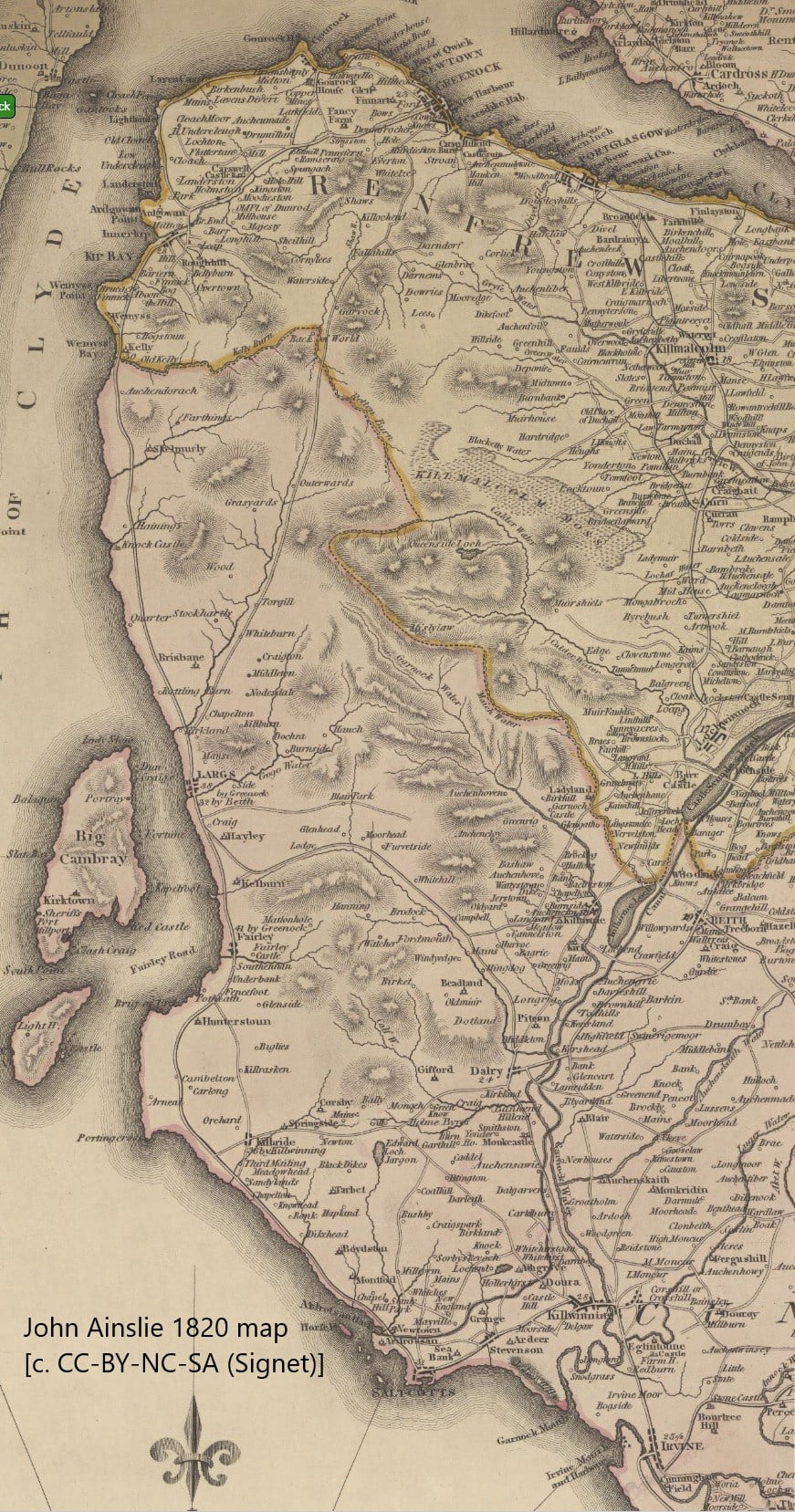
The family home is in ‘Garnock’, “pleasantly situated between Irvine and Kilwinning”, named after the adjacent river. The characters are fictional, but at that time there was indeed a settlement just where ‘Garnock’ was imagined - half-way between Irvine and Kilwinning lay the coal-mining hamlet of Bartonholm. It is not possible to prove that Galt’s ‘Garnock’ is Bartonholm, but no other township fits the location. The main source of information on North Ayrshire at the time is George Robertson, writing in the same years as Galt was writing ‘The Legatees’; he shows Bartonholm on the map in his book and records : “Part of it, nearly encircled in a link of the Garnock, is among the richest holme-land in the county”. In the ‘Legatees’, Rachel Pringle mentions “the fragrant bean-fields, and the peaceful groves of my native Garnock” in contrast to the noise and activity of Greenock docks. Half a mile to the west was the hamlet of Snodgrass, not shown on Robertson’s map, but shown on John Ainslie’s 1820 map; was this why Galt named the other local minister as Dr Snodgrass?
The family start their journey in Irvine, the ‘Gudetown’ of Galt’s ‘The Provost’, published the following year. Robertson records: “The two Head Inns, as they are called, are very respectable. A stage-coach passes and repasses, three days in the week, through this town, betwixt Ayr and Greenock.” The Inn where they meet the coach is not named . Galt, in his autobiography records that, as a child, he was taken every year “to Greenock for a short time”. Another local mention in the ‘Legatees’ is where Rachel Pringle recalls “skipping from tomb to tomb in the breezy churchyard of Irvine” with her friend Miss Isabella Todd. Galt well knew the Irvine Old Parish churchyard, and Mrs Pringle’s cousin, Miss Mally Glencairn, is placed by the author in a house in Kirkgate , the street leading to the church.
On reaching Ardrossan, the family are impressed by the Tontine Inn. A ‘tontine’ was an annuity scheme often used to raise capital to fund building projects, including coaching inns. (The family home built in Greenock for George Robertson, whose books we reference, is now the Tontine Inn in that town; the original 1802 Tontine Inn was elsewhere.) The Inn in Ardrossan was built as a guest residence in 1806-07 for the 12th Earl of Eglinton (Hugh Montgomerie, d. 1819), who laid the foundation stone for Ardrossan Harbour in 1806 with the vision of creating a major port connected to Glasgow and Paisley by canal. Robertson records: "The Inn, or Hotel is, unquestionably, the most superb of any, out of a great town, in Scotland, and in none is better accommodation afforded. It has 10 public rooms, and 18 bed-rooms; the suit [sic] of offices, in a stile [sic] conformable to it, is ample and commodious, with 28 stalls for horses, and 7 stances for carriages. The whole, including its elegant furniture, cost Lord Eglinton, at least, £10,000." No wonder the Pringle family admired it! The New Statistical Account records that the baths of Ardrossan were projected by the late Earl, on the tontine principle, in 1807.
Rachel also comments: “the people of Saltcoats - a sordid race - complain that it will be their ruin, and the Paisley subscribers to his lordship's canal grow pale when they think of profit”. Ardrossan harbour did indeed become the main harbour in the area. Of the canal, only 11 miles was built before funds ran out and investment ceased.
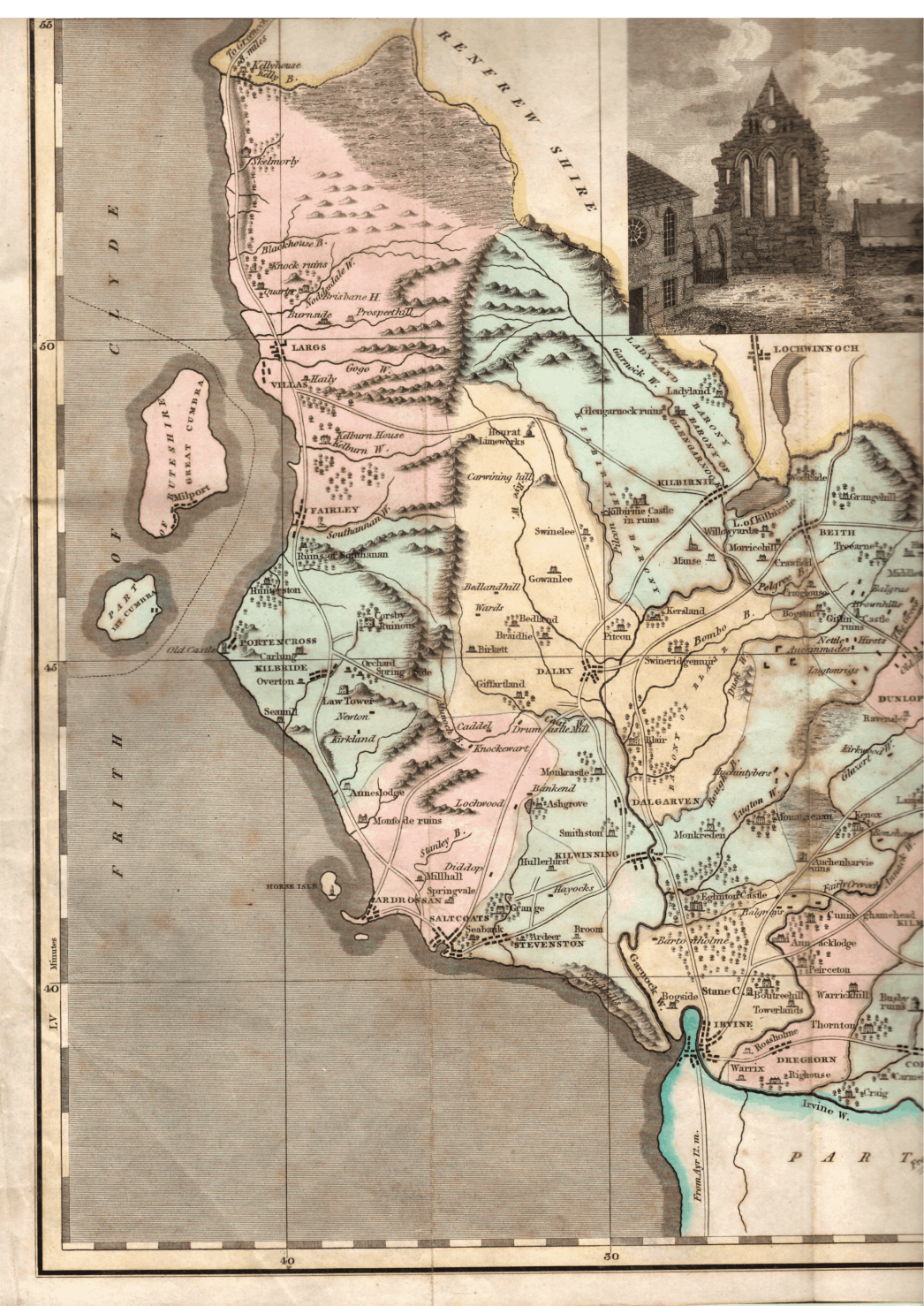
Proceeding up the coast, the family enjoy views of Arran. At Kilbride, now West Kilbride, they “passed under the walls of an ancient tower . . a lofty relic of warlike ancestors”. Some have suggested this is Crosbie Tower, shown on the 1820 map as ‘ruins’. Robertson describes Crosbie as “an old mansion, in good preservation” but adds “it is hardly to be seen through the woods with which it is surrounded”; today’s later large house is not visible from the road north, and the road certainly did not pass near the walls of Crosbie. The tower noted by the Pringles is, in this writer’s opinion, almost certainly Law Tower (now Law Castle), on the edge of West Kilbride; Robertson describes it as “a stately fabric, though now roofless . . possibly erected about 1468” and illustrates it with a sketch. It seems to have been built for Princess Mary, sister of King James III, as a wedding gift upon her marriage in 1467 to Thomas Boyd, Earl of Arran. Although the coach may not have travelled the steep road beside it, the comment “under its walls” probably reflects its location on Law Hill, overlooking West Kilbride, and the “warlike ancestors” comment may be prompting us to think back to the 15th century. Its white walls are clearly visible from today’s Hunterston Road roundabout on the John Galt Way, looking south-east to the landward side of West Kilbride.
Rachel Pringle refers to Bute as “dear to departed royalty”. Rothesay Castle , famous for its long and close association with the Stewart kings of Scotland, features Scotland’s only circular curtain wall, with four projecting towers that were added after the Norse siege of 1263. Following the accession of the Stewarts to the throne of Scotland in 1371, the castle became a favourite residence of King Robert II and King Robert III, who died here in 1406 . Additional building work was carried out in the reigns of James IV and James V. It was rendered ruinous in 1660-85.
Rachel Pringle is next moved by the sight of “the cloistered ruins of the religious house of Southenan [sic], a nunnery in those days of romantic adventure when to live was to enjoy a poetical element . . such a sweet, sequestered retreat”. On Robertson’s 1820 map, it is simply “Ruins of Southanan [sic]”. On the 1857 OS map it is shown as “St Annan's Chapel (in ruin)”. Robertson, in a section on land ownership, records : “It was long the property of the Lords Sempil, who had a remarkably pleasant mansion here, now in ruins, at the foot of a steep bank clothed with wood, and within 100 yards of the sea. At the first breaking up of that great family, about 100 years ago, it was purchased by Alexander, ninth Earl of Eglinton, and is at present the property of his grand-daughter Lady Mary Montgomery Burgess.” Historic Environment Scotland states: “Ruin of what was once an extensive structure, having had a high enclosing wall, with a courtyard and an arched entrance porch to the west, defended with shot-holes; there has been a considerable range of dwelling-house accommodation, two stories in height along the north side and smaller buildings on the east. The lands of Southannan were granted to Lord Semple in 1504 but the castle probably dates from the end of the 16th century, some of the existing remains appearing to be still more modern. The chapel that was attached to it has entirely disappeared.” The ‘B’ listing of the “Ruin of Old Abbey, Southannan” was removed in 2016. Robertson does not mention the abbey ruins. The coat of arms on the old gateway is that of the Montgomeries. A visit today, in from the main road, on a private road which walkers can use with discretion, may well prompt similar thoughts of a “sweet, sequestered retreat”.
At Largs, the Pringles see the barrows of those who fell in the great battle – the battle which ended Norse control of the Western Isles and Argyll on 2nd October 1263, now celebrated by the Pencil Monument of 1912, a giant Viking on Largs seafront, and the excellent exhibition in Vikingar!. King Alexander III of Scotland had driven out the Norse Jarls who had controlled the Western Isles since the early 12th century. King Haakon III of Norway was furious and set out to re-establish control. In 1263, having ravaged the west, he anchored off the Cumbrae Islands. Autumn gales drove some of his ships aground at Largs. The Battle of Largs, on 2nd/3rd October, may have been more of an inconclusive battle influenced by the weather. In any case, the Vikings withdrew and Haakon died while wintering in Orkney on the journey back to Norway. The encounter proved of huge significance, as it left a powerful Scottish king ruling a country which would be united for the first time. Seventeen years before writing the ‘Legatees’, Galt, aged only 24, had written and published his 'sort of Gothic epic', “The Battle of Largs”, accepted by Constable for the “Scots Magazine” in 1803 and 1804.
The “barrows of those who fell” are little remembered now, but were well known in 1820, particularly to the young Galt who had regularly travelled that route in the 1780s. At Hayley, “a vast tumulus . . erected over the bodies of the slain, as thought, at the battle of Largs” was discovered in 1772 by Mr Wilson searching for stones on his land – in it were discovered five stone apartments with skulls presumed to be of chiefs and bones supposed to be of ‘common warriors’ - these remains probably belonged to a much earlier time than the 13th century.
Another ‘barrow’ is the large mound in the centre of Largs, at Gallow Hill, behind the main street: now overgrown and not easily accessible, the barrow or mound (about 25 by 9 yards), and another one a short distance to the south-east, are described by Robertson as “evidently artificial . . probably erected as tumuli over the dead, or in honour of their memory . . [and] may be regarded as corroborative evidence of a battle having been fought near to the town of Largs, and not at all improbable, that it was the very battle . . between the Norwegians and the Scots”. The one in the centre of Largs was excavated in 1873 by Dr Phené, who thought might be the burial place of the Norsemen killed in the battle, though it is now thought to be a Norman-period motte of the 12th century .
After Largs, Rachel Pringle is impressed by the route along the foot of stupendous precipices and looks up at “the ancient castle of Skelmorlie, where the Montgomeries of other days held their gorgeous banquets and that brave knight who fell at Chevy-Chace came pricking forth on his milk-white steed”. As the main road has no pavement, the John Galt Way takes walkers to the landward side of the castle onto a country road with magnificent views. Skelmorlie castle was ‘ancient’, in that the oldest portion was built in 1502 and added to, including the angle turrets, in 1636; the Montgomeries owned it from about 1460 to the 1970s. But while the “gorgeous banquets and brave knights” – Rachel’s fond imaginings of a chivalrous past – no doubt existed, there seems no link between Skelmorlie and the ballad of Chevy Chase; the comment is based on a quote from Edmund Burke in 1790, ‘the age of chivalry is gone’. The castle exterior is unchanged from Galt’s time. An 1880s sketch of the castle is included below.
The stream that divides the counties of Ayr and Renfrew is the Kelly Burn (not the River Calder, which, in the middle of the county, flows to the east). The Kelly Burn is now the boundary between North Ayrshire and Inverclyde. The Kelly House seen by the Pringles was a large white mansion house built by Mr John Wallace, the “West India planter”, who acquired the Kelly Estate in 1792 . After his death in 1803, his son Robert planned to build a marine village of 200 villas around the bay, though possibly only four of the eventual 36 villas were built by Galt’s time – they were let to wealthy Glasgow merchants, and Rachel’s “social villas . . Glasgow manufacturers” describes the development at the time, where ‘social’ suggests community rather than today’s subsidised housing. Kelly House itself was destroyed by fire in 1913 in suspicious circumstances and is now the site of the caravan park.
Rachel commented: “At a dull drive of about two miles, and then at once we entered the pretty village of Inverkip.” We can agree with both comments, the uninteresting road past the entrance to the now-gone Inverkip Power Station, followed by a pretty village, now thankfully bypassed by today’s main road.
We then hear that after “a picturesque and romantic pass, we entered a spacious valley”. The short pass is pleasant and today passes a distillery (Ardgowan; tours daily except Mondays), but the 1.5 mile spacious Spango valley suffers today from the remains of the extensive, one-mile long, IBM manufacturing plant (1954-2016, making typewriters and bank terminals, then personal computers), an area which could now do with much tidying and rehabilitation. Walkers will be pleased that there is a country road alternative to the Spango Valley dual carriageway.
At Greenock, the family note “a magnificent edifice erected for balls” – this may be the Exchange Buildings, built in 1814, described by local historian Daniel Weir in 1829 as “fitted up in a splendid manner”, and since demolished.
Alison Lumsden, Professor in English Literature at Aberdeen University, has noted this interaction of historical fact with imagination, has referred to it as a “re-remembering of the past” and has drawn attention to Galt writing (in ‘Ringan Gilhaize’) as a first-person account. Similarly, the first-person letter from Rachel Pringle lends immediacy to the story of the Pringle family’s journey as they view historical sights and current developments along the route. Many of Galt’s readers would have been familiar with the locations he highlights, and today’s readers can still enjoy the responses of Rachel and her family to the sights and scenery of North Ayrshire and Inverclyde.
Rounding off this summary, there is nothing unusual about authors using real locations as backdrops to stories, such as, to name but three, Graham Greene setting ‘Our Man in Havana’ in Cuba, Charles Dickens setting ‘Oliver Twist’ in London, and Andrew O’Hagan incorporating Ayrshire scenes in the London-based ‘Caledonian Road’. Teasing out the details of John Galt’s locations in ‘The Ayrshire Legatees’ has proved an interesting investigation.
Ian J Dickson
August 2026